Header mapping

Utility Surveys & Mapping

MRMS > Utility Surveys & Mapping

Precision Surveys for Asset Owners & Delivery Partners

At MRMS, we specialise in utility surveys and GPS drain mapping, delivering precise, high-quality data that supports the management, maintenance, and development of water and wastewater infrastructure. Our services provide network operators and delivery partners with a clear understanding of underground assets, enabling safe, efficient, and well-informed project planning.

Using advanced surveying technology and extensive field expertise, we accurately locate and map water mains, sewers, and associated utilities to support asset management, capital delivery, and operational maintenance. This helps reduce the risk of service strikes, unplanned disruptions, and costly delays, while ensuring compliance with industry standards and environmental obligations.

Our detailed mapping and reporting solutions are designed to meet the demands of complex, regulated infrastructure environments. With MRMS as your survey partner, you gain dependable, actionable data that supports long-term network resilience, informed decision-making, and the successful delivery of water infrastructure projects.

mapping intro side
CCTV side image monitor

Our Utility Survey Solutions

Utility surveys are critical in the design and planning phase of any construction or infrastructure project. Accurate underground mapping helps enhance site safety, reduce project delays, optimise cost efficiency and ensure regulatory compliance. We employ a combination of cutting-edge survey techniques to provide highly detailed reports on underground utilities and services:

  • Ground Penetrating Radar (GPR) & Electromagnetic Location: Detects and maps buried assets like pipes, cables, and conduits.
  • CCTV Drainage Surveys: Inspects sewer and drainage systems to assess their condition.
  • Inverted Scanning & Gyroscopic Mapping: Offers enhanced accuracy for complex underground networks.
  • 3D BIM (Building Information Modelling) Integration: Provides detailed underground service maps within a digital construction model.
  • Plant Avoidance Mark-Up & PAS128 Compliance: Ensures safe excavation and adherence to best practices.

GPS Asset Mapping

GPS drain mapping, also known as asset mapping, is the most accurate method for identifying drainage system layouts. Traditional methods, such as dye testing, lack the precision of GPS-integrated technology, which pinpoints drainage assets with accuracy up to 2cm. Our expert GPS asset mapping solutions provide:

  • Accurate drain identification: Precisely locate manholes, gullies, sewer lines, and other drainage assets.
  • Depth and flow analysis: Identify whether drains handle foul or surface water and determine directional flow.
  • Property boundary & maintenance insights: Establish ownership responsibilities for drainage infrastructure.
  • Seamless project integration: Essential for pre-construction planning and ensuring regulatory compliance.
CCTV side image GPS mapping


Precision Mapping for Essential Infrastructure

We combine advanced detection technology with proven geospatial expertise to deliver accurate utility mapping and reporting. Our services provide the clarity needed to manage buried infrastructure safely, efficiently, and in full compliance with industry standards.

  • Advanced survey technology: Utilising state-of-the-art equipment for precise mapping.
  • Experienced professionals: Skilled surveyors with expertise in utility detection and geospatial mapping.
  • Comprehensive reporting: Clear, accurate data to support decision-making.
  • Regulatory compliance: Ensuring adherence to PAS128 and industry standards.

Specialist Survey & Mapping Equipment

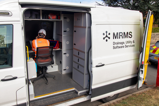
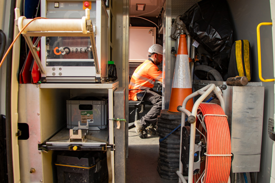
Custom-equipped CCTV Vans

Our state-of-the-art CCTV vans feature advanced customisation and are equipped with a range of digital inspection and mapping tools to undertake above and below-ground asset surveys. The vans also feature a workplace area complete with a desk and viewing screens.

CCTV equipment crawler

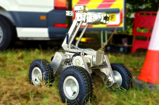
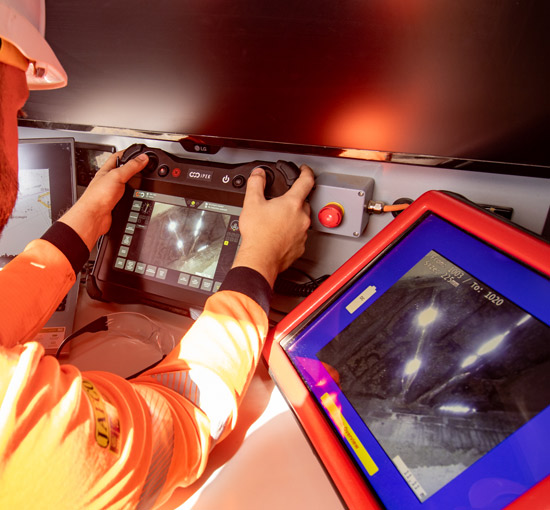
Mainline Crawler Systems

Our vans come fitted with mainline HD crawler systems, robot inspection devices that traverse pipes while delivering a high-definition image back to our vans on the surface for easier defect detection. The systems are operated remotely from the van and include a 300m cable reel for superior reach.

CCTV side image Zone

Zone 2 ATEX Approved

Our survey and mapping equipment is Zone 2 ATEX-approved, meaning it can be used in environments where an explosive atmosphere may be present for a short period if a leak or malfunction happens. The tools feature non-sparking materials, low surface temperatures, and appropriate electrical protection methods.

EXPERIENCE

Working with MRMS

We guarantee the highest quality of service and safety at all times.

  • Years of Experience
  • Highly Skilled Specialists
  • Fast Response Times
  • Latest Technologies & Equipment
  • Efficient and Cost Effective Solutions
  • Full Regulatory Compliance
man